
Water Quality

HYGEOS is also involved in the Global component of the Copernicus Land Monitoring Service (CLMS). Indeed, Polymer is implemented in the near-real-time operational processing chains to retrieve the Lake Water Quality products suite at 300m resolution from the Sentinel-3/OLCI reflectance and at 100m resolution from the Sentinel-2/MSI. This suite of products includes the turbidity of the lake which varies seasonally both with the discharge of rivers and growth of phytoplankton, the trophic state index as an indicator of the productivity of a lake in terms of phytoplankton and the lake surface reflectance which describes the apparent colour of the water body. More than 4260 lakes all around the world are covered.
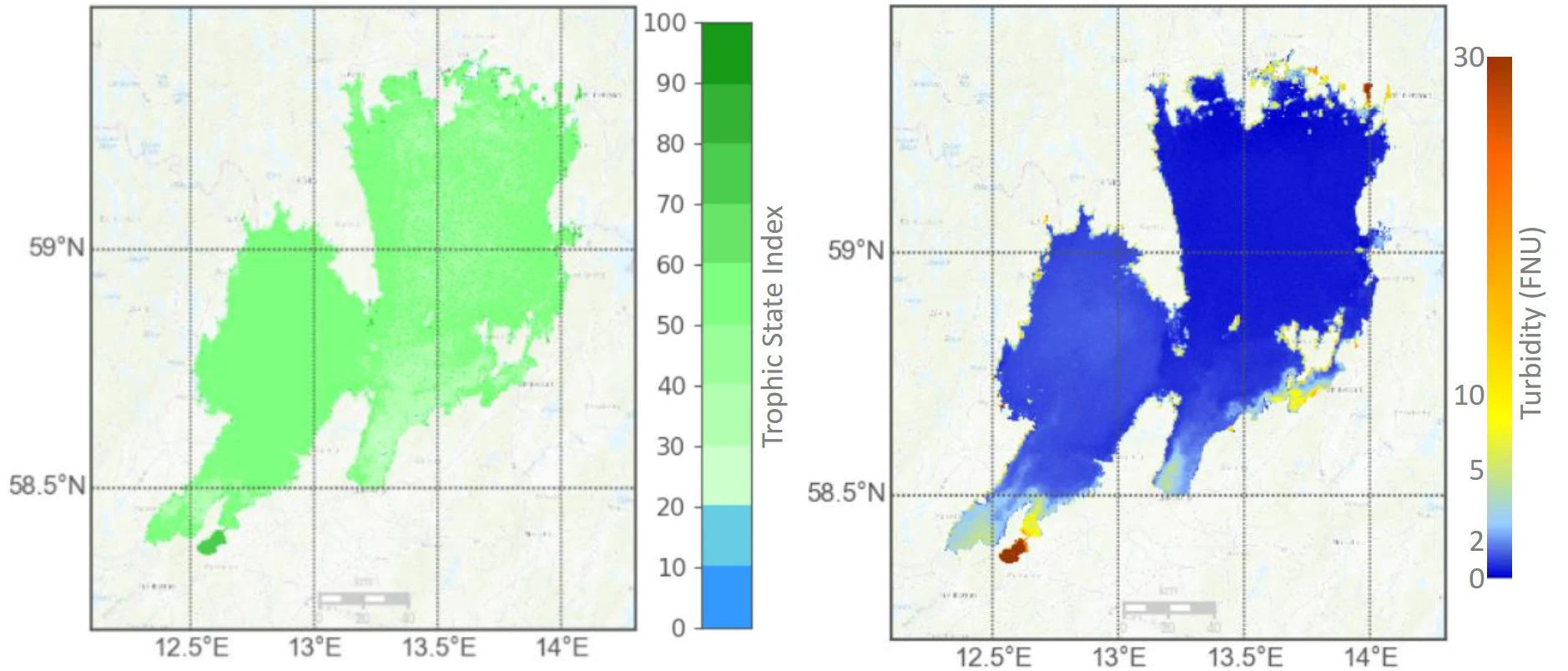
Tropic State Index (left) and Turbidity (right) of Lake Vänern, Sweden, on 11 April 2018 as provided by the Copernicus Global Land Service.
HYGEOS has developed for EUMETSAT a Bright Pixel Correction for the Sentinel-3/OLCI sensor. This correction, as well as a totally revised Clear Water Atmospheric Correction algorithm with new aerosol modelling, detection and new capabilities regarding aerosol layer height retrieval, is now included in the robust and versatile Ocean Colour Standard Atmospheric Correction module (OC-SAC) which is being integrated into the OLCI operational processor of EUMETSAT in order to deliver the Collection 4 of Copernicus Ocean Colour products. Always looking for improvement, HYGEOS has developed, using Polymer as a baseline, an alternative atmospheric correction scheme (SACSO), using a spectral matching approach and including an uncertainty propagation scheme, to improve the quality of the OLCI water reflectance, in particular in presence of absorbing aerosols. Polymer, as well as the alternative SACSO processor, are both integrated into a modular Ocean Colour prototype processor deployment and validation framework. HYGEOS is also developing a daily Photosynthetically Available Radiation (PAR) product from Sentinel-3/OLCI sensor which would extend the list of operational Level 2 Ocean Color products distributed by EUMETSAT.
HYGEOS also works on the ocean colour products derived from geostationary satellites operated by EUMETSAT. HYGEOS contributes to develop prototype processing for retrieval of ocean colour products, such as water turbidity and chlorophyll concentrations, from SEVIRI on MSG and the upcoming FCI on MTG for open ocean, coastal and inland water coverage. The SEVIRI and FCI processing will be embedded in the multi-mission modules of the EUMETSAT’s existing ocean colour prototype processor with the goal to raise the ocean colour from European geostationary satellites to an operational level.
Thanks to its experience on the exploitation of geostationary imagery, HYGEOS has developed an Sargassum detection algorithm from the Advanced Baseline Imager (ABI) on GOES-16 geostationary platform covering the Caribbean area. With its 10-minute temporal resolution, ABI allows to extend the satellite coverage to the whole day. HYGEOS algorithm is now integrated into SAMTool, the operational Sargassum detection system operated by CLS, in complement of ocean colour products derived from the combination of 6 polar orbiting satellites. Output are delivered to Meteo-France for its mandate of monitoring Sargassum in the Caribbean and French Guyana and to the French Ocean Data Information and Service.
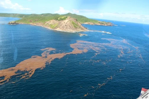
Sargassums off French Antilles
In the continuity, HYGEOS and CLS participate in an extension of the CMEMS through its OC-TAC by developing a new set of Sargassum data products derived from multiple satellite observations: wide swath sensors (Aqua/MODIS, Sentinel-3/OLCI), high spatial resolution sensors (Sentinel-2/MSI, Landsat-8/OLI) and high temporal resolution with geostationary satellites (GOES-16/ABI). These products will contribute to develop a new ecosystem of downstream applications aiming to react to the massive landings of sargassum seaweed that occurred periodically on the shorelines of the Tropical Atlantic Basin, causing devastating effects on local economies.